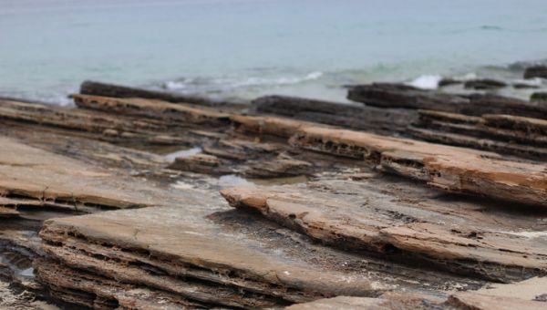
Tung Ping Chau is a crescent-shaped island set in the east of Mirs Bay. It is the easternmost outlying island of Hong Kong. Relatively flat and of extremely low elevations, the island really lives up to its name. On the east, it faces the Mirs Peninsula (or Dapeng Peninsula) and Nan’ao town in Shenzhen. Tung Ping Chau snatched second place in the ‘Top 10 Hong Kong Attractions’ list jointly compiled by the Friends of the Country Parks, Lions Clubs International District 303 - Hong Kong & Macau and the Agriculture, Fisheries and Conservation Department in December 2006. It forms part of the Plover Cove Extension Country Park. Studded with 65 million-year-old shale rock eroded by nature, the island is famously known as one of the ‘four natural wonders of Hong Kong’, making it a hot spot for a trip out of downtown or a geographical expedition. The waters near the island form Hong Kong’s fourth marine park – the Tung Ping Chau Marine Park. Its shore is home to a variety of coral and shellfish.
Historically, there were 10 villages on the island, namely Chau Mei, Tai Tong, Chan Uk, Lei Uk, Tsau Uk, Lam Uk, Tsoi Uk, Chau Tau, Sha Tau and Nai Tau.
The changing coastal landscape of the island has given rise to a few unique tourist attractions, such as Kang Lau Shek (‘Watchman’s Tower Rocks’), Lung Lok Shui ('Dragon Descend into Water') and Cham Keng Chau ('Chop Neck Islet’). A country trail built by the Agriculture, Fisheries and Conservation Department makes a circuit of the island. You can just follow it and take a tour around the island. Kang Lau Shek is an intertidal paradise for urchins, sea anemones, chitons, barnacles, neritids and more.
Suggested Route: Public Pier > Tai Tong Wan> Cheung Sha Wan > Chau Mei Kok> Cham Keng Chau > Lung Lok Shui > Lan Kwo Shui > Kang Lau Shek > A Ma Wan > Public Pier